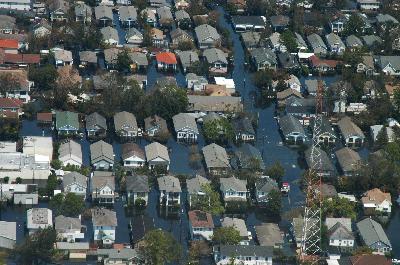
New Orleans, LA 9/4/05 -- Aerial view of houses in New Orleans swamped by floodwaters after Hurricane Katrina. Photo by: Liz Roll, FEMA
Continued from previous page
First, most media outlets and federal officials have reported that 80% of New Orleans is under water. That's an area the size of Manhattan, the Bronx and Brooklyn combined. Most of the major routes for delivering aid and conducting rescues are under water or significantly damaged. And let's not forget that the Katrina disaster area is equivalent to having all of New Jersey, Delaware, Connecticut, Maryland and one of half of Pennsylvania, New York and Virginia (about 90,000 sq. mi. in all) declared disaster areas. As such, some resources moved close to the anticipated disaster area ahead of the storm have been damaged or lost, and some of those who might otherwise pitch in to help, are picking up the pieces in their own communities.
It is difficult to say how prepared the residents of New Orleans and other coastal areas in the path of Katrina were. However, it is likely that many were not sufficiently prepared. I do not know what level of outreach has been provided over the years to educate the residents in coastal Mississippi, Alabama and Louisiana, but I suspect that more could have been done. But that is true of most areas across the country.
For example, many areas of New Jersey and New York City are at risk for serious damage associated with a flood surge and winds from a significant hurricane. Yet most residents and commuters are not aware of the hurricane evacuation plans developed for their area. Many do not know what areas are outside the predicted danger zones or where the established hurricane evacuation shelter serving their area is.
One article, published by the Civil Engineering Magazine in 2003, "The Creeping Storm" by Greg Brouwer provides a useful overview of the history of actions taken over the last 40 years to protect New Orleans. Following Hurricane Betsy in 1965, Congress passed the Flood Control Act, which appropriated funds to increase the height of the levees around the northern side of the city. The U.S. Army Corps of Engineers established a design criteria for the improved levees which is equivalent to a level needed to withstand a fast moving Category 3 hurricane (the Saffir-Simpson scale used to categorize hurricanes did not exist at the time the criteria were set).
As a result of the 1965 legislation, the system of levees forming a ring around the northern half of the New Orleans to protect it from surging waters in Lake Pontchartrain were set to be completed within the next decade. According to Brouwer, construction of a similar system around the southern half of the city would probably take several more years.
Yet nearly 40 years after beginning these projects, the Corps was reassessing whether the current height of the levees is sufficient. The levee system was designed for a fast-moving Category 3 storm, based on rudimentary models available in the 1960s. Brouwer states that larger storms or a slow-moving Category 3 storm could potentially overtop the levees, leaving New Orleans under 20 feet of water. Exacerbating the problem is the fact that the coastline has been subsiding over the last 40 years, and protective coastal marsh that would absorb some of the impact of a hurricane is only half as wide as it was when the levees were designed. According to Brouwer, experts said a flood likely with a Category 4 or 5 hurricane would probably shut down the city's power plants and water and sewage treatment plants and could even take out its drainage system. The American Red Cross estimated that between 25,000 and 100,000 people would die in this scenario. Today, the answer is painfully clear: the levee height was not sufficient.
Even when risks are known, the pace of bureaucratic action is slow and halting. In his article, Brouwer reports, according to Al Naomi, the Corps Project Manager: "Any concerted effort to protect the city from a storm of Category 4 or 5 will probably take 30 years to complete." According to Brouwer's article, the feasibility study alone would have cost as much as $8 million. Even though Congress had authorized the feasibility study, funding had not yet been appropriated. When funds were made available, the study would take about six years to complete. Beyond the studies, there would be many more steps to complete designs and begin, much less complete construction.
The political will and public interest to commit the time and money to such projects before a disaster are often lacking, even when the risks are great. Is it an election year? Does the project have popular support? These are the considerations that often drive decisions; not need, not risk, not who's at risk, their annual income or skin color. This lack of interest until disaster hits is seen over and over again--close to home and farther away.
Funding to repair aging dams in New Jersey was largely eliminated until five dams breached during heavy flooding a year or so ago causing significant impact to residents downstream. After the fact, funding was immediately restored. Hundreds of millions of dollars were appropriated for protection of the New York/New Jersey transit system; yet little of it was spent prior to the bombings in London. There are similar examples across the country where important projects, that may save lives, languish.
Has the response fallen short of what was needed? Have people suffered unimaginable losses? Have people died waiting to be rescued? Absolutely! Is it helpful to the victims to spin the disaster to make a political point, to wrangle over what party is at fault? Is it helpful to cry racism? Absolutely not!
Return to main page to comment on article.
To read the 2003 Civil Engineering Magazine article, click below: